
【Meeting Notice】Tutorial in conjunctio with The ISPRS Geospatial Week 2017
Time: September 16-17 Location: pending
(1.)
Why Topology Matters i n Spatial Cognition and Analysis?*
Bin Jiang
Faculty of Engineering and Sust ainable Development, Division of GIScience
University of Gä vle, SE-801 76 Gävle, S weden
Emai l: bin.jiang@ hig.se
Topology refers to topological r elationship a mong spatia lly or geometrically coh erent entities such as rivers, m ountains, b uildings, stre ets, and cities, so it differs fundamentally from the same notion used in geographic information systems (GIS) (Figure 1a). In the G S literature, topology refers to relations hip between geometric lements such as pixels, points, lines, and polygo ns, and it is therefore a basic concept for structuring nd reasoning geospatial informatio , e.g., TIGE R data structure and Max Egenhofer or Eliseo Clementini’s top ological mo els. However, these geometric ele ments are mechanistically defined and imp osed, so th a t they possess little semantic meani ngs in our perception and cognition. The t opology w e intend to discuss in t his tutorial enables us to see the u nderlying scaling or fractal or living stru cture of fa r more small things th n large one s, or far m ore less-connect d than well- connected ( Figure 1b), o r far more eaningless hings than meaningful ones. This living structure, also called who eness or life or beauty, discovered by Christopher Alexander through his life’s work The Nature of Order, is d efined mathematically as a recur sive structu re, exists inherent ly in space and matter p ysically, an d reflects in our minds a nd cognition psychologic ally. It is through the notion of wholenes s or wholen ess of spatia l configurations – “not something about the way the are seen, but somethin about the way they are” – that top logy matters in spatial c ognition. In other words, what is reflecte d in the minds arises out of the structure that in heres in the physical world. Spatial cogn ition is, first and fore most, a mode of perceiving the deep structu e or the wholeness of space.
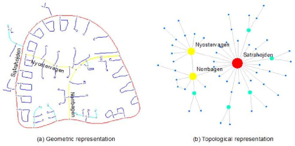
Figure 1: (Color onlin e) Illustratio n of geometric and topological repre sentations
(Note: Geom etric repres entation (a), due to geom etric details such as loca tions, length , and direction s, must be tr ansformed in to the topol ogical representation (b) in order to see clearly th e scaling pr operty of far more less c onnected than well conn ected. The topological representation bears no geometric details at all.)
This tut orial is organ ized throug h a series of lectures, ha nds-on exercises, and dis cussions sur rounding the concepts of topology, scalin g, and beaut y. It was giv en previously on several occasions, e.g., as a
- This tutorial was initially submitte d to COSIT 2017, but wa s kindly declined because i t is not in line with the traditiona l COSIT the mes. Thanks to the COSIT organizers, in particular Dr. Clementi ni, for inviting me as a keynote s peaker to add ress the prestigious confer ence.
training school of the COST Action 1305 mainly for geospatial analysis of big data(http://www.tu1305.eu/content/training-school). This time we will concentrate on why topologymatters in spatial analysis and cognition, linking scaling and beauty. The beauty refers to structuralbeauty or wholeness at deep level rather than surface beauty that is often considered to be in the eye ofthe beholder. This tutorial targets to researchers both young and senior in the field of geospatialinformation science and cartography. Participants must have their laptops with basic tools installedsuch as Excel, Matlab, ArcGIS 10.x, and Axwoman 6.3, and some head/tail breaks tools (linked to theWikipedia of head/tail breaks), and we will provide sample data for hands-on exercises. Internetaccess is essential for the tutorial.
Tools to be used:
Axwoman: http://fromto.hig.se/~bjg/axwoman/
Head/tail breaks: http://en.wikipedia.org/wiki/Head/tail_Breaks
NaturalCitiesModel: http://www.arcgis.com/home/item.html?id=47b1d6fdd1984a6fae916af389cdc57d
Data to be used:
OpenStreetMap: http://download.geofabrik.de/
Nighttime imagery: https://ngdc.noaa.gov/eog/dmsp/downloadV4composites.html
Brightkite: https://snap.stanford.edu/data/loc-brightkite.html
Topics to cover:
Topological and scaling ways of thinking for understanding space and human behaviour
The third definition of fractal for better understanding urban structure and dynamics
The image of the city arising out of the underlying scaling or living structure
A mathematical model of beauty for characterizing geographic forms and processes
It is recommended to read the following papers prior to the tutorial.
https://www.researchgate.net/publication/282310447_A_Fractal_Perspective_on_Scale_in_Geography
https://www.researchgate.net/publication/319527592_Why_Topology_Matters_in_Spatial_Cognition_and_Analysis
(2.)
Preconference Tutorial on Spatiotemporal Data Analytics
Bo Huang
Professor
Department of Geography and Resource Management
Associate Director
Institute of Space and Earth Information Science (ISEIS)
The Chinese University of Hong Kong, Hong Kong
This half-day session will cover the models related to spatiotemporal database design and subsequent spatiotemporal analysis with consideration of autocorrelation and heterogeneity. A spatiotemporal object model and associated query language, spatiotemporal logistic model and geographically and temporally weighted regression (GTWR) as well as their applications will be described and discussed in detail.
In this session, you can also get a chance to learn two software packages: ChangeAnalyst (an ArcGIS Addin for land use change modeling) and GTWR (an ArcGIS Addin for spatiotemporal data analysis). The GTWR package includes three models: geographically weighted regression (GWR), temporally weighted regression (TWR), and GTWR. Among them, TWR and GTWR were devised by Huang et al. (2010).
This is a highly interactive session, where you can ask questions directly to the developers of the models and software packages.
Recommended Readings
Chu, H. J., Huang, B., and Lin, C. Y., 2015. Modeling the spatio-temporal heterogeneity in the PM10-PM2.5 relationship. Atmospheric Environment, 102: 176-182.
Wu, B., Li, R. R., and Huang, B., 2014. A Geographically and Temporally Weighted Autoregressive Model with Application to Housing Prices. International Journal of Geographical Information Science, 28(5): 1186-1204.
Huang, B., Wu, B., and Barry, M., 2010. Geographically and Temporally Weighted Regression for modeling spatio-temporal variation in house prices. International Journal of Geographical Information Science, 24(3): 383 – 401.
Huang, B., Zhang, L., and Wu, B., 2009. Spatio-temporal analysis of rural-urban land conversion. International Journal of Geographical Information Science, 23(3): 379 – 398.
Huang, B. and Yao, L., 2003. A spatio-temporal database approach to dynamic segmentation. Transportation Research Record: Journal of the Transportation Research Board. 1836: 118-125.
Huang, B., 2003. An object model with parametric polymorphism for dynamic segmentation. International Journal of Geographical Information Science. 17(4): 343-360.
Huang, B. and Claramunt, C., 2002. STOQL: An ODMG-based spatio-temporal Object Model and Query Language. In D. Richardson and P. Oosterom (eds.), Advances in Spatial Data Handling, Springer-Verlag.